Monday, April 30, 2007

Hawaii trip - day 6, part 2

Friday, April 13th continued...

After stopping for lunch in Hilo, we continued south to Volcanoes National Park, where there was a lot to see. It's helpful not to think of the volcano as just a single mountain peak that might erupt from the cone (like Mt. St. Helens) but as a volcano "complex" with numerous potential points of eruption, along with subterranean lava flows which occasionally surface above ground, and lots of other evidence of volcanic and seismic activity.

Many areas of the park convey a sense of what the earliest days of Planet Earth might have been like... barren landscapes with no vegetation, rising steam, interaction between rock and water and fire. In a very real sense, the world here is "not finished" yet; in fact this part of the earth is just being born as the Kilauea volcano continues to dump lava into the ocean, expanding the island to the southeast.

The steam vents were among the neatest attractions -- not to mention being the easiest to view -- at Volcanoes National Park. Warmed by underground volcanic heat, rainwater rises as clouds of steam from holes in the ground. Lower your hand or fingers toward one of the vents, but be prepared to pull it back in a hurry... it's HOT! This might be the closest most park visitors get to feeling the volcano's thermal power.


steam vents along Crater Rim Drive


checking out the steam vents

ignoring the signs
We drove Chain of Craters Road from its intersection with Crater Rim Drive near the 4000-foot elevation, east toward the coast. We got a great view of the ocean beyond the lava fields as we approached sea level. Eventually, we reached a point where the road was closed, blocked by a 2003 lava flow (and others dating back to about 1983. Beyond that, it's hiking country... we didn't have time to walk the 4+ miles each direction to view the active lava flow, but we did walk to a spot where we could see large clouds of steam and smoke rising from the ocean -- this was where the new lava was entering the water.

right through a lava field - Chain of Craters Road


heading toward the coast - Pacific Ocean in the background


These portable park buildings had to be re-located in 2003 before an active lava flow consumed them.


Road sign encased in lava from the 2003 flow

remains of a road covered by lava


on the side of a volcano - heading uphill on Chain of Craters Road
Even though we didn't have time to hike to the active lava flow, we still enjoyed our visit to Volcanoes National Park. It's not every day that you can see volcanic-heated steam rising from cracks in the ground, or walk on a part of the earth that's younger than your kids!

After leaving the volcano, we continued south to Punalu'u State Park (which we had hoped to visit on Wednesday but we did South Point instead). Punalu'u has a black sand beach, and is well known as a nesting location for sea turtles. We were a little disappointed; the beach was small, the sand was coarse and difficult to walk on, and the turtles all appeared to be sleeping. The black sand beach at Pololu was a lot nicer. We started back to our hotel, stopping for dinner at Quizno's in Hilo. We arrived back at the hotel around 2130... 14 hours on the road! Saturday would be our last day on the island, and in the afternoon we'd be starting our journey back to Texas. Stay tuned ...

WSC
np: Adrenalin O.D. - Humungousfungusamongus

Labels: , ,

Friday, April 27, 2007

Hawaii trip - day 6, part 1

Friday, April 13

We had been on the Big Island since Tuesday afternoon and we hadn't seen the volcano yet. I guess that kind of narrowed it down as to what we'd be doing on Friday. Since neither of us thought much of the drive south through Kona on Wednesday, we decided to take the "other" route to Volcanoes National Park, east through Waimea and then southeast through Hilo. This would give us a chance to visit two other attractions on our "to do" list: the Waipio Valley overlook and Akaka Falls.

We arrived at the Waipio Valley overlook around 9 am and stood around for 15 minutes or so, enjoying the view. The scenery is similar to what we had seen the previous day at Pololu. However, Waipio Valley features a road you can drive clear to the bottom -- IF you're properly equipped. We knew in advance that the rental car companies didn't allow their cars in the Waipio Valley. Even if we hadn't known, the ominous "25 % grade" sign probably would have deterred us from proceding further. When we arrived, we were the only ones there, but we knew it was time to leave when several carloads of people showed up.


Waipio Valley overlook - Friday, April 13


driving south on Highway 19 along the Big Island's east coast
Next, we drove southeast toward Hilo. We took a short side trip up to Akaka Falls State Park. Akaka Falls is a dramatic 400-foot waterfall in one of the many valleys draining water into the Pacific on the island's northeast coast. There are actually two waterfalls -- Akaka Falls and the smaller Kahuna Falls. The state parks facility provides a paved pathway to access good views of both with little physical effort (walking distance - less than 1000 feet). During our visit, the weather alternated between light rain and mist. We were sure that this was very common. There were enormous trees and plants with huge leaves everywhere we looked; we felt like we were in a jungle or a rainforest. This was the most crowded of any of the tourist attractions we had visited so far. (A couple of tour buses arrived around the same time we got there). But the crowds weren't too bad, and the scenery was well worth the stop. We were as impressed with all the vegetation as we were with the waterfalls!


The path to Akaka Falls


Akaka Falls


All these branches were part of the same tree!


lots of green leaves


Akaka Falls flora

Next stop: Hilo (for shopping and lunch) and then the volcano! Stay tuned...

WSC
np: Waylon Jennings - "Are you sure Hank done it this way" on KHYI 95.3-FM
nr: Ruby El Hult - Northwest Disaster

Labels: , ,

Wednesday, April 25, 2007

Hawaii trip - day 5

Tuesday, April 12 - our best day yet

We weren't ready for another full morning at the beach, so after breakfast we set out to do some sightseeing. Our objective for the morning was to visit the Pololu Valley overlook on the far north end of the island. One of the amazing things about Hawaii is how drastically the climate and vegetation can change in just a few miles. This seems to be true of all the islands, but was especially noticeable on the northern part of the Big Island. We drove north from Kona through semi-arid conditions resembling the Davis Mountains in far west Texas (mountainsides covered with yellow prairie grass) but over a stretch of less than 10 miles, the vegetation and cloud cover increased dramatically as we entered the island's "wet side". A series of valleys along the island's northeast shore funnels the watershed from the Kohala Mountains down to the Pacific Ocean. The Pololu overlook, located a few miles east of the town of Hawi, provides an elevated view of one of these valleys and the dramatic seaside cliffs which border it; and provides access to a hiking trail leading down to a black sand beach below.


the view from the Pololu overlook.


We arrived at the overlook around 0900 and found just two other vehicles at the parking area. We could see someone down on the beach, and decided to walk on down the trail. It took us about 25 minutes to reach the bottom. Near the bottom, we met three other people who were getting ready to hike back up, and then we walked out onto the beach.


K on the black sand beach at Pololu


all alone on the best beach on the island


The black sand (it's actually very dark gray) is made up of crushed particles of the black volcanic rock that makes up this portion of the island's coastline. At Pololu, the sand was very fine, and comfortable to walk on (but since black sand absorbs heat it can become very hot!) With ominous cliffs on both sides of us and the black sand under our feet, this was by far the most unique beach I have ever been to. The best part was, we were the only ones around! For over half an hour, we had one of the world's most spectacular beaches completely to ourselves. We felt truly blessed.
The sandy portion was only a couple hundred yards wide... beyond that, the shore consisted of rocks and stones. We walked over some of the rocks toward the cliffs to the southeast, but the footing was difficult so we turned around, and started back up the trail. The hike up was quite a bit more strenuous than the hike down... gaining 500 feet in elevation is roughly equivalent to climbing a 50-story building! But the view we had down at the bottom was worth every step of the climb back up. On our way up, we passed a small army of hikers preparing to descend on the beach. We had obviously gotten there at the right time!


The Pololu Valley, as viewed from the bottom...


Panting and sweating, we finally made it back to our "jeep car", and drove back west. Northwest of Hawi, back on the island's "dry side", we found a road leading down to a rocky portion of the coast. Here we were, less than 10 miles from a thick belt of lush, tropical vegetation, and we were driving a road that looked for all the world like one of the park roads circling Lake Nasworthy out near San Angelo! We spent a few minutes looking at the tidepools, and then headed back to the hotel.

It may look like west Texas lakeside scenery, but no... this is definitely the Pacific.


West of Hawi, I convinced K to pose with our "jeep car".


K wanted to do some shopping, and I didn't want to risk adding to my sunburn by going to the beach during "high sun", so I joined her for a trip down to Kona to check out Hilo Hattie's, kind of a one-stop tourist gift shop for shirts, coffee, macadamia nuts, and all things Hawaiian. Later, we treated ourselves to some "plate lunches" at L&L Hawaiian Barbecue, a nice "no frills" local eatery near Hilo Hattie's, and then started back toward the hotel. On our way north, we stopped to look at a lava tube that we had noticed north of the airport.
Much of the landscape in this area consists of a relatively recent lava flow from Mauna Kea toward the island's western shore. In some areas, all you see is black and brown jagged rock... in others, vegetation is beginning to gain a foothold, and the lava is less evident. During the times when lava flows were active, "lava tubes" formed in certain locations. As the lava's surface hardened, molten lava continued to flow beneath the surface, resulting in the formation of tubes -- essentially, "pipelines" which carried the lava downhill away from its source. Over the years, some of the hardened lava above the tubes has collapsed and eroded, creating openings and entrances where one can look -- and even walk -- inside. The one north of the airport was the only one we saw near a highway anywhere on the island. So we stopped to have a look...

lava tube north of Kona Airport


fractured earth north of Kona


Back at the hotel, I got some drinks and headed to the beach while K took a nap back at the hotel. Later, we had dinner at the hotel's steak house / sushi bar, and then we went to bed early, resting up for what would be our most ambitious day of sightseeing on Friday. Stay tuned for the next report...
WSC
np: Neneh Cherry - "Move with me"
nr: Ruby El Hult - Northwest Disaster


Labels: , , ,

Hawaii trip - day 4

a brief diversion...

We had checked into our hotel north of Kona on Tuesday afternoon. We walked around the hotel looking for somewhere to eat, but it was the mid-afternoon lull between lunch and dinner, and most of the restaurants were closed. So we decided to go to the beach for a while and just have an early dinner instead. Back at our room, we found a bottle of wine on ice -- a gift from the hotel to help us celebrate our anniversary. We finished most of the bottle, headed to the poolside bar for more drinks, and then hit the beach for a couple hours. Toward sunset, as I looked out toward the horizon I saw some water spray into the air. A minute or two later, I saw it again... and then something jumped out and made a huge splash. I showed K where to look and we both saw it -- at least two whales were swimming together about 1/2 to 3/4 of a mile from shore, spouting water, jumping from the water and then crashing down, slapping their tails, etc. I'd never seen a whale before, and here we were, watching two of them from the beach about a hundred yards from our hotel room! Better yet, we were pretty much the only people left on the beach, and we were the only ones who saw them. This was definitely one of the neatest experiences of the entire trip.

Where we stayed


The Hapuna Beach Prince Hotel & Resort. April 2007.
The Hapuna Beach Prince is located about 20 to 25 miles north of Kona Airport, on the northern portion of the Big Island's west coast. It's located about 5 miles south of the town of Kawaihae. The Hapuna Beach Prince is a "sister" hotel to the Mauna Kea Resort, which is located a half-mile to the north. The hotels provide a shuttle van to take guests from one hotel to the other. Other than the hotels, there isn't much development in the immediate area. If you want to shop or eat someplace else besides the hotel, you have to drive north to Kawaihae, east to Waimea, south to Kona, or to another resort. (There are a few others within a 15-minute drive to the south). Hapuna Beach itself is very nice, especially for an island that isn't exactly known for having the best beaches. Much of the Big Island's shoreline is rocky, and Hapuna Beach is one of the largest on the island, consisting of about a half-mile stretch of white sand between the rocky areas. The hotel shares its beach with the Hapuna Beach State Park, but there is plenty of room, and it never reached a point of being what we would have called "crowded". From all except the northernmost portion of the beach, mountains on the island of Maui are visible to the north, looming above the ocean 40 to 50 miles away in the distance.


Early morning on Hapuna Beach. Mauna Loa, Hawaii's second-highest mountain peak, is visible in the background.

An early morning view from our lanai.

K enjoys the view from our fourth floor room.

Driftwood and rocks near the Hapuna Beach Prince Hotel.

As for the hotel itself, it was built in the early 1990s. Rooms are located in three different "wings" extending out from the main building which houses the lobby, offices, shops, and some of the restaurants. The pool was large, the beach was very close, the staff was friendly, and our room was clean and comfortable. The hotel had several restaurants, but not all of them were open the whole time we were there. We really enjoyed our four-night stay there, and we'd definitely stay there again if we return to the Big Island.

Wednesday, April 11

We decided to set aside Wednesday as a pool and beach day. After breakfast, we headed down to the beach. Unfortunately, all of the hotel's beach chairs were already taken (the attendant told us it's best to get there very early, as the state park only allows them to set out a certain number of chairs). So we headed to the pool. It didn't take me very long to get sick of listening to screaming kids playing in the pool, and moms yapping away on their cell phones (in fact, it took less than 60 seconds!) I was in kind of a bad mood at this point, so I headed back to the beach and eventually found some vacant chairs. K and I spent the next 3 hours on the beach, which ended up being a little too much sun for both of us, even with sunscreen. After lunch, we decided to spend our afternoon doing something else.

We had wanted to visit the black sand beach and sea turtle nesting area at Punalu'u, and the green sand beach and overlooks down at South Point, so we headed south down the island. Approaching Kona, we got stuck in a hell of a traffic jam. With only two-lane highways in each direction, even through the middle of town, Kona and its neighboring towns to the south are unable to efficiently handle the traffic. Everything was stop and go, stop and go (mostly stop) for several miles. It reminded me of Branson, Missouri back around 1990! The traffic cost us close to an hour of time, forcing us to adjust our plans. Instead of Punalu'u, we decided to check out South Point, which was a shorter drive. We'd visit Punalu'u on Friday instead.
"Like Branson in 1990!" Traffic on Highway 11 south of Kona.

Located on the southern tip of the Big Island, South Point is the southernmost location in the United States. A nearby beach is reported to feature green sand (well, brownish-green; it's tinted with particles of a mineral called olivine). We arrived there too late in the day to see the beach (you have to hike to it), so we settled for just watching the sunset from the ledges overlooking the ocean. But the view was well worth the time it took to drive down there... we'd highly recommend it as a great place to catch a sunset!

K at South Point

the happy couple


Windmills and sunset at South Point
We picked up some dinner on our way back to the hotel, and called it a night around 10 pm. That's all for Wednesday... stay tuned for the next installment.
WSC
nr: Ruby El Hult - Northwest Disaster
np: Johnny Cash - "When the man comes around" on KHYI 95.3 FM

Labels: , , , ,

Monday, April 23, 2007

Hawaii trip - day 3

Tuesday, April 10 - Aloha, Honolulu; Aloha, Big Island...

On Tuesday morning, it was time for us to leave Waikiki. We packed up and checked out of our hotel and met Susan & Greg and their family for breakfast at Sam Choy's - Breakfast Lunch & Crab. Unfortunately, the only crab I saw offered on their breakfast menu was some kind of crab salad omelet. Their menu did feature several variations of the Hawaiian loco-moko platters -- usually some kind of combination of rice and meat topped with a fried egg -- but in the end I went with what I viewed to be the "safest" choice -- fried eggs with toast, sausage, and Spam. I wasn't disappointed.


K and Susan at Sam Choy's

After breakfast, we had plenty of time to get to the airport to return our rental car and catch our flight. It didn't even occur to me that we probably could have snuck in a visit to the Hawaiian Railway Society's museum over near Ewa. Oh well, maybe next time. Meanwhile, I got my transportation jollies by photographing this Matson container passing Sam Choy's on its way to the Honolulu port complex...


This Matson truck helped me get my transportation "fix"...

A Hawaiian Airlines Boeing 717 taxis toward the runway, about to leave Honolulu

The business of moving people between the various islands is an interesting one. Most of the islands are too far apart from one another for surface transportation (i.e. passenger and autmotive ferries) to be very feasible, although I've heard that some sort of "super ferry" might be starting up soon. Basically, if you want to get to another island, you're stuck flying the friendly skies (unless you own your own boat!) Three different airlines -- Aloha, Go!, and Hawaiian -- offer several daily flights between the islands. Think of them as Hawaiian equivalents to Southwest, serving a smaller and more captive market. The flights are all quite short... I remember two years ago, our flight from Honolulu to Maui was just over 30 minutes. On this trip, our flights between Honolulu and Kona Airport on the Big Island were just over 45 minutes. Amazingly, the flight attendants still have time to roll the beverage cart down the aisle, serving passengers soft drinks and juice. You have about 5 minutes to finish your drink before they have to come back through the cabin to collect the empties!

Just after takeoff - an aerial view of Honolulu

Above Kaho'olawe, the small uninhabited island just off the south coast of Maui.
We arrived in Kona as scheduled, picked up our baggage and rental car, and headed north 20 miles or so to our hotel. We spent the rest of the afternoon and evening relaxing at our hotel, enjoying some time on the beach, and having dinner.
Stay tuned for more...
WSC
nr: Ruby El Hult - Northwest Disaster
np: John Prine - "Let's talk dirty in Hawaiian", a song that I meant to install on K's Ipod before we left, but I never got around to it...

Labels: , , , , , ,

Sunday, April 22, 2007

Hawaii trip - day 2, part 2

Monday April 9 - driving tour of the north shore

If you remember back to part 1, Bill had agreed to show me around the island of Oahu while K and Susan had their "spa and shopping day".

One of our objectives for Monday was a tour of Oahu's north shore, the less developed and less congested side of the island. The north shore features dramatic scenery, accessible beaches, and some of the biggest waves you'll see on the islands -- in fact, the north shore is widely regarded as one of the best surfing locations anywhere in the world.


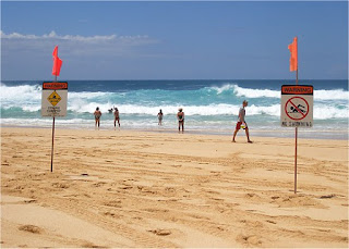
Ominous signs warning of rough water are posted along most of the north shore beaches.


A small crowd was on hand at Sunset Beach to watch the surfers...


Several photographers were on hand, hoping to get shots of the surfers.


Parts of the north shore coastline were rocky, and were incessantly smashed by large waves.

The north shore's single highway was blocked by a rock slide near Waimea, so we had to turn around and head back east. We'd have to go all the way back to Kane'ohe and back through Honolulu and then go north to complete our tour.
Roadside "shrimp shacks" appear to be sort of a north shore trademark; we stopped for lunch at Romy's in Kahuku for a feast of shrimp and prawns, which are harvested daily from ponds adjacent to Romy's "shack". The prices were a bit on the high side, but the shrimp was delicious... it was well worth the time we took to stop.


Romy's Shrimp & Prawns in Kahuku (Oahu north shore)


Later, we enjoyed the scenery as we headed back east toward Kane'ohe...
eastbound on Highway 83


a windblown tree near Kane'ohe

After circling around through Honolulu and then heading northwest, we concluded our tour at Matsumoto Shave Ice in Hale'iwa. Matsumoto's is widely regarded as one of the best -- and is certainly one of the most famous -- of Hawaii's shave ice establishments. A family-owned business, Matsumoto's has been around for over 50 years. Customers can choose from a variety of flavors, and can even specify the addition of ice cream (recommended!) or "Azuki" beans to their shave ice. While you wait in line (there is always a line) you can scan the walls, admiring dozens of Matsumoto t-shirt designs, which are of course available for purchase.
The legendary Matsumoto store...
After making our obligatory shave ice and t-shirt purchases, we headed back to town for dinner.
On Tuesday, K and I left Honolulu and caught a flight to the Big Island. Stay tuned for more...
WSC
np: Junior Brown - "Surf Medley" from the album "Semi Crazy"
nr: Ruby El Hult - Northwest Disaster

Labels: , , ,

Saturday, April 21, 2007

Hawaii trip - day 2, part 1

Monday, April 9 - Honolulu scenes

We had the whole day to spend on the island of Oahu. K had plans to go shopping and go to a spa with Susan; I was planning on meeting up with Bill for a drive along the north shore. First, I took a couple shots from our hotel balcony...


Looking south along Beachwalk St. in Waikiki. The constuction site in the foreground will be the location of a Donald Trump project, a high-rise tower housing hundreds of hotel suites and luxury codominiums. In the background is the Outrigger Reef, where we stayed during our 2005 visit. It's currently undergoing renovations and remodeling, but appeared to still be open.


early morning view of Waikiki
After breakfast, Bill and I met up to start our day. Before heading for the north shore, we took a hike up to the top of 760-ft Diamond Head peak for a great view of the city. The trail is usually crowded with school groups and other tourists, but it isn't too bad if you get an early enough start.


Looking west from Diamond Head toward Waikiki and Honolulu


looking south from Diamond Head


not for those seeking solitude... the trail up Diamond Head was crowded in both directions

After Diamond Head, we headed for Kane'ohe and drove west along the north shore. (I'll post those photos in a separate entry). Later in the afternoon, we had time for more sightseeing around downtown Honolulu before we met K and Bill's wife and Susan and Greg for dinner...

Honolulu's Iolani Palace, which once housed Hawaiian royalty


The Honolulu state capitol building is... well... "unique" to say the least...


After dinner at Keo's Thai Cuisine in Waikiki (highly recommended!) we walked along Lewers checking out some of the new shops. (Demolition crews were tearing down old apartment buildings here during our 2005 visit; it's amazing how fast they put all this new stuff up!) Then we got some dessert and called it a night. In the morning, K and I would head to the airport to catch our flight to Kona on the Big Island.
Stay tuned for more... the next entry will cover our driving tour of Oahu's north coast.
WSC
nr: Ruby El Hult - Northwest Disaster
np: 10,000 Maniacs - Hope Chest

Labels: , , ,